Optimize Land Use with Automated Spatial Insights

Field Cross is an advanced module for monitoring, analyzing, and managing spatial data to ensure sustainable land use and regulatory compliance. It automates data collection, assesses environmental risks in real-time, and provides accurate mapping insights for better decision-making.

Frame-427319643-2 (2)
Designed to provide full project oversight
Frame-427319643-1 (1)
Customizable for any industry or project scope
Frame-427319643 (1)
Simple and intuitive

Environmental Risk Management

The module proactively identifies and mitigates land-use risks by leveraging predictive analytics, deforestation monitoring, and real-time spatial data processing capabilities.

shape, abstract, blob, stars, spark, sparks, sparkle, shine, night, pattern, magic, dust, fairy

Geospatial Oversight

Field Cross automates land-use analysis, tracks environmental changes in real time, and centralizes spatial documentation to enhance accuracy and accountability across all operational levels.

Compliance & Certification Preparedness

Field Cross streamlines certification processes through automated spatial analysis, built-in version control, and timely alerts for critical environmental milestones.

OUR FEATURES

User empowerment & personalized experience

Customizable workflows, real-time reporting, and dynamic dashboards to enhance operational efficiency and control.

Intelligent Geospatial Management

Field Cross enables customizable spatial workflows, real-time data visualization, and centralized dashboards to maintain regulatory alignment and effectively manage environmental risk.

Deforestation Monitoring

The module continuously tracks land-use changes, monitors deforestation trends, and ensures compliance with regulatory frameworks through real-time satellite data analysis.

Workflow Automation

Field Cross eliminates the need for manual geospatial analysis by automating data collection, integrating document control systems, and providing continuous real-time mapping updates.

Notifications and Alerts

Users are equipped with real-time alerts for emerging environmental risks, upcoming certification deadlines, and key compliance milestones.

Features

IMPLEMENTATION PROCESS

Step by step, growing with thePeterson SolutionsFamily

1 (1)

Configure Sites and Spatial Data

Set up project areas, geospatial layers, and data sources to ensure Field View reflects your operational footprint from day one.

2 (1)

Set Compliance and Monitoring Objectives

Define your environmental goals such as land-use validation or deforestation monitoring and establish the criteria for ongoing compliance.

3 (1)

Streamline Workflows and Centralize Evidence

Automate spatial tasks, track activities, and consolidate all environmental records in one platform to ensure traceability and audit readiness.

STRUCTURE

Key KPIs

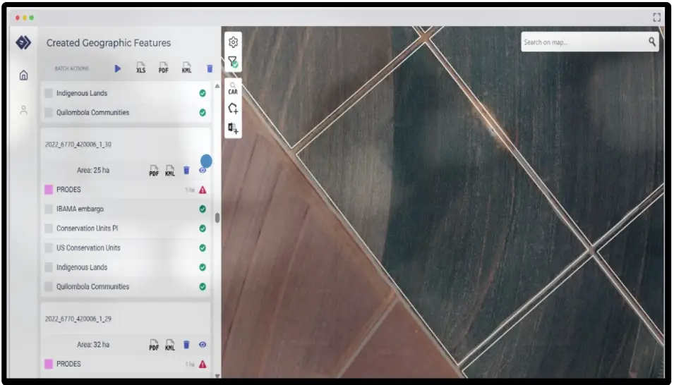
Field Cross enables seamless geospatial management by automating land-use analysis, mitigating environmental risks, and enhancing regulatory oversight. The module improves operational transparency, minimizes compliance errors, and reduces audit preparation time through real-time tracking and intelligent workflow integration.

Compliance Ready
11 %
Error Reduction:
10 %
Risk Mitigation:
10 %
Total Land Plots
0 units

FAQ

What is Field Cross used for?

It provides a fast and intuitive user experience, generating concise, one-page reports with an authenticable QR code

How frequently is satellite data updated?

Can I verify deforestation-free status here?

Yes, our Field View platform allows to verify this by analyzing the data with different filters, allowing the identification of deforestation-free status

Send us a message.